Drone Stockpile Surveys & Volumetric Calculations
Eliminate inventory guesswork and hazardous manual grade walking. TerraX3D delivers rapid, certified drone volumetric calculations, cut/fill balancing, and 3D digital elevation models for mines, quarries, bulk aggregate yards, and construction earthworks across South Africa.
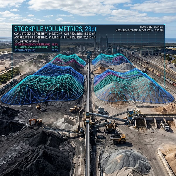
End-to-End Geospatial Volumetrics
Precision Cut, Fill & Stockyard Inventory
Traditional ground surveying of loose stockpiles is dangerous, slow, and leaves gaps in complex top surfaces. Our UAV LiDAR and photogrammetry workflows capture millions of coordinate points across the entire stockpile footprint in minutes.
Stockpile Volume & Tonnage
Automated base surface triangulation and digital terrain modeling calculate exact cubic meters (m³), combined with custom bulk density factors for certified financial stock auditing.
- Coal, Aggregate, Sand & Ores
- Monthly audit variance tracking
Cut & Fill Earthwork Analysis
Compare actual site ground progress directly against design CAD/TIN surfaces. Quantify cut volumes, fill deficits, and verify civil earthmoving contractor claims.
- Heatmaps with elevation differentials
- Interim progress billing validation
Quarry & Pit 3D Terrain Mapping
Generate high-resolution digital surface models (DSM) and ortho-rectified aerial basemaps of active quarry faces, highwalls, haul roads, and bench progressions.
- Highwall slope stability inspection
- Haul road gradient & safety auditing
Technical Deliverables & Compatibility
Certified outputs delivered directly to your civil engineering, GIS, and ERP platforms.
| Deliverable Component | Format / Specification | Typical Use Case |
|---|---|---|
| Certified Volume PDF Report | PDF, Excel CSV | Financial auditing, monthly inventory reconciliation |
| 3D Point Clouds | LAS, LAZ, E57, XYZ | Civil 3D, AutoCAD, Carlson, Bentley MicroStation |
| Digital Elevation Model (DEM/DTM) | GeoTIFF, ESRI Grid, DXF Contours | Hydrology modeling, drainage, slope analysis |
| High-Res Orthomosaic | GeoTIFF (sub-2cm GSD), ECW, KML | GIS visual layers, site boundary auditing, Google Earth |
Mining & Volumetric Guides
Stockpile Auditing & Mine Survey Resources
Monthly Mine Stockpile Volumetric Survey Services in Mpumalanga & Limpopo
SAMREC/JSE-ready ROM stockpile volume calculations, bulk density tonnage conversions, and 2026 ZAR rate cards.
Precision Stockpile Volumetrics Using UAV Photogrammetry in Mining
How RTK/PPK drone surveys achieve ±1.0% volumetric precision while eliminating toe-and-crest walking hazards.
Tailings Storage Facility (TSF) Freeboard & Volumetric Monitoring
Multi-return LiDAR embankment deformation tracking and capacity calculations for South African mining dams.
Volumetric Surveying FAQ
How accurate are drone stockpile volumetric calculations?
Using RTK/PPK-enabled drone LiDAR and high-resolution photogrammetry tied to surveyed Hartebeesthoek94 ground control points (GCPs), our volumetric calculations consistently achieve accuracy margins within 1% to 2% of actual physical volume across irregular ROM coal, chrome, platinum, and aggregate stockpiles.
How are stockpile volumes converted into tonnage?
We compute net cubic meters (m³) by triangulating the high-density 3D surface mesh against the verified base pad TIN model, then multiply by your laboratory-certified bulk density (t/m³) and moisture correction factors to produce audit-ready financial tonnage reconciliation reports.
What is the turnaround time for a drone stockpile survey?
On-site UAV flight capture typically requires 1 to 3 hours depending on quarry or stockyard footprint without halting haul trucks or loaders. Complete 3D volumetric PDF reports, Excel CSV reconciliations, and CAD contour files are delivered within 24 to 48 hours.
Can drone volumetrics calculate earthwork cut and fill balances?
Yes. We run surface-to-surface and surface-to-design elevation differential models in Civil 3D to accurately quantify excavation cut volumes, embankment fill requirements, and net earthmoving balances for interim contractor payment certificates and bulk earthworks verification.
Need Stockpile & Quarry Inventory Audited?
Contact our aerial geomatics team today for certified volumetric surveying and cut/fill analysis across Gauteng, Mpumalanga, Limpopo, and South Africa.