Aerial Drone Surveying & Photogrammetry Services
Acquire survey-grade aerial topography and ultra-high-resolution orthomosaics. TerraX3D deploys RTK/PPK-guided commercial drone fleets across South Africa, transforming hundreds of hectares of terrain into classified CAD elevation models, contour maps, and digital twins in record time.
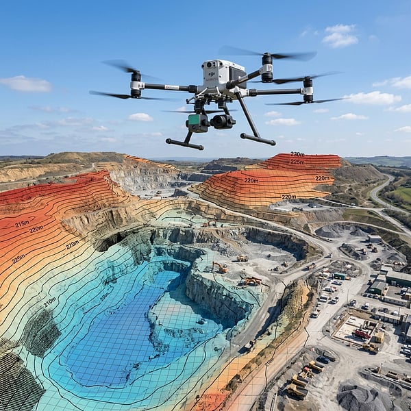
High-Density Aerial Geomatics
Georeferenced Orthomosaics & Topography
From greenfield civil development sites to agricultural estate boundaries and linear pipeline corridors, our drone surveying workflows deliver complete spatial clarity without disrupting live ground operations.
High-Res 2D Orthomosaics
Thousands of high-resolution aerial images stitched into a seamless, distortion-free, georeferenced aerial basemap at sub-2cm resolution.
- Site progress tracking & auditing
- GIS asset layers & boundary mapping
Digital Elevation & Contours
Generate digital terrain models (DTM), bare-earth surfaces, and vector elevation contours at 0.25m, 0.5m, or 1m intervals for civil design.
- AutoCAD & Civil 3D DXF contours
- Stormwater flow & catchment analysis
3D Photogrammetry Meshes
Textured, photorealistic 3D reality meshes of architectural structures, bridges, heritage monuments, and open-cast pits for BIM visualization.
- OBJ, FBX, 3D PDF, & Cesium 3D Tiles
- Virtual site walkthroughs & VR models
Deliverables & Coordinate Standards
Export formats ready for instant import into CAD, GIS, and Engineering software.
| Deliverable | Format / Specification | Accuracy / System |
|---|---|---|
| Georeferenced Orthomosaic | GeoTIFF, ECW, JPG2000 | < 2cm GSD / Hartebeesthoek94 Lo Grid |
| Digital Elevation Model (DEM/DTM) | 32-bit GeoTIFF, XYZ Grid | 1-3cm vertical absolute accuracy |
| CAD Topographic Vector Contours | DWG, DXF, SHP (0.25m / 0.5m / 1m) | AutoCAD Civil 3D, MicroStation ready |
| 3D Point Cloud | LAS, LAZ, E57 (RGB Colourized) | 100-300 pts/m² density |
Aerial Geomatics Guides
UAV Photogrammetry & Topographic Resources
LiDAR vs. Photogrammetry for Topographic Surveying in South Africa
When to deploy RTK drone photogrammetry vs. multi-return aerial LiDAR across bushveld, quarries, and civil corridors.
Hartebeesthoek94 & Lo Grid Coordinate Systems in Civil Surveys
How TrigNet base stations, SAGEOID2010 orthometric heights, and Lo19–Lo31 grids ensure seamless Civil 3D alignment.
Solar PV Farm & Wind Turbine Topographical Site Surveys
500+ hectare daily drone mapping, hydrology drainage modeling, and subsurface cable route clearance for IPP projects.
Photogrammetry & Drone Survey FAQ
What ground sampling distance (GSD) resolution can drone photogrammetry achieve?
Our high-resolution calibrated metric UAV camera sensors achieve sub-1.5cm Ground Sampling Distance (GSD) per pixel, enabling precise extraction of road kerbs, manhole covers, drainage channels, and structural breaklines across hundreds of hectares.
What is the difference between drone photogrammetry and aerial LiDAR?
Drone photogrammetry reconstructs 3D terrain models and true-colour orthomosaics from overlapping aerial photographs—ideal for bare earth, quarries, and solar farms—whereas aerial LiDAR uses active laser pulses to penetrate dense vegetation canopies.
Do you tie surveys into the South African Hartebeesthoek94 coordinate system?
Yes. Every aerial survey is georeferenced using dual-frequency RTK/PPK GNSS receivers and surveyed Ground Control Points (GCPs) tied directly to South Africa's official Hartebeesthoek94 datum (WG19 to WG31 Lo meridian grids) and SAGEOID2010 orthometric heights.
What CAD and GIS file formats are delivered?
We deliver georeferenced GeoTIFF and ECW orthomosaics, classified 3D point clouds (LAS/LAZ), Digital Terrain Models (DTM), 0.25m to 1.0m DXF/DWG vector contours, and textured 3D meshes compatible with AutoCAD Civil 3D, ArcGIS, and QGIS.
Ready for Precision Aerial Site Mapping?
Contact our UAV geomatics flight team today for high-resolution aerial photogrammetry and topographic surveying anywhere in South Africa.